WORLD OCEAN PROJECT
WORLD • Commemorative Ocean Acre Registry

Your Place
in the Ocean.

Choose a real location on the world's ocean and create a personalized COAR — Commemorative Ocean Acre Registration with a unique WORLD number, coordinates, mapped location, ocean information and collectible document package.

A WORLD COAR is a commemorative geographic registration and collectible. It is not a deed and does not convey legal ownership of ocean water, seabed, mineral rights, fishing rights, navigation rights, sovereignty or real property.
PUBLISHED CRUISE ROUTE
🚢
WORLD COAR: HI-PAC-2026-001847 Hawaii • Pacific Ocean • 10 Commemorative Ocean Acres
Approx. center: 20.65° N / 156.55° W
Featured Memorials

Explore Protected Memorial Areas

These historically significant locations are protected from general WORLD registration and are presented for remembrance, history and education.

More than a certificate

A Real Place With a Story

WORLD connects each commemorative acre to real geography so the recipient can explore the waters, nearby routes, wildlife, history and seafloor around the registered location.

#

Unique COAR Number

A permanent WORLD registration number tied to the selected ocean location.

⌖

Mapped Coordinates

Latitude, longitude, region and an outlined commemorative acre on the WORLD map.

≋

Ocean Profile

Depth, nearby places, marine life, public ocean data and notable features when available.

🚢

Published Cruise Routes

Publicly available cruise itinerary and published route information near the registered plot.

Create a COAR

Choose Your Ocean Location

Click the map or enter latitude and longitude. WORLD snaps the point to fixed 10-acre grid cells so registered areas can later be checked for overlap.

Select a WORLD Location

Click an ocean location or enter coordinates. The selection snaps to a fixed 10-acre WORLD grid cell. Use the + / − map buttons to zoom.

MAP OVERLAYS
WORLD GRID SELECTION
Grid Cell: Not selected
Area: 10 acres minimum
Center Latitude: —
Center Longitude: —
Approx. Cell Size: 660 × 660 ft per 10-acre cell
3D Seafloor STL: Pending
Opens a bathymetry preview centered on your currently selected WORLD grid location.
Loading ocean/land boundary data…
Selection tool is active. Land selections are blocked. Public purchasing remains disabled while checkout and overlap checking are completed.
Protected memorial zones are blocked from public selection, including Pearl Harbor and the RMS Titanic wreck area.
Click the emblem you want printed on your COAR certificate.
Selected certificate emblem: Sea Turtle
Concept package total
$220
Concept pricing only
Preview My COAR

TEST CART 0

Select an ocean grid area, then add it to the test cart.

PURCHASING COMING SOON

Public purchases are not available in REV20A5. You can choose a location, preview a COAR, and create a free account now. Live PayPal checkout will be turned on in a later non-A revision.

Browse the map and create an account on this site. Payment remains off while registry and overlap checking are finished.

Hawaii • Pacific Ocean

Sample WORLD location record
AVAILABLE
PUBLISHED CRUISE ROUTE
COAR NUMBERHI-PAC-2026-001847
AREA10 Commemorative Ocean Acres
LATITUDE20.650000° N
LONGITUDE156.550000° W
NEAREST MAJOR ISLANDMaui
PUBLISHED CRUISE ROUTESNearby route data available
Explore the surrounding ocean

Turn On WORLD Data Layers

Turn layers on and off while viewing a COAR location: routes, wildlife, wrecks, platforms, and depth.

Published Cruise Routes
Historic Shipwrecks
Offshore Platforms
Depth / Seafloor
Marine Protected Areas
Nearby Ports
WH
⚓
⛽
WORLD COAR HI-PAC-2026-001847
White dashed line = published cruise-route information • Yellow outline = commemorative acre
WORLD Ocean Life Explorer

What Lives Near HI-0001?

Click an animal or habitat to explore species associated with the surrounding Hawaii region. These are regional range, habitat and seasonal-occurrence records—not live tracking and not a guarantee that an animal is inside the exact commemorative acre.

Marine life connected to this location

Whales Near This COAR

Species shown here are associated with the surrounding Hawaii region based on published government and scientific information. This does not mean a whale will be physically present inside the exact commemorative acre at any particular time.

WHALE
WHALE
WHALE
WORLD COAR HI-PAC-2026-001847
Hawaii • Pacific Ocean
Yellow outline = commemorative acre • Whale symbols represent regional species information, not live animal locations.
Hawaii • Pacific Ocean

What could be swimming around your part of the WORLD?

Hawaiian waters support resident and migratory whales and dolphins. Some species occur seasonally, while others use Hawaiian waters year-round. WORLD can connect a COAR to the best available public information for that particular region.

BEST-KNOWN SEASONHumpbacks: generally November–April; peak January–March.
WHY HAWAII?Warm waters provide important breeding, calving and nursing habitat for humpbacks.
REGIONAL RESIDENTFalse killer whales include Hawaii-associated populations that move throughout island waters.
WINTER VISITORSNOAA surveys have also documented minke and other baleen whale species in winter.
WH

Humpback Whale

Megaptera novaeangliae
WHEN IN HAWAIIGenerally November through April, with the greatest abundance around January through March.
WHY THEY COMEBreeding, giving birth and nursing calves in warm Hawaiian waters.
PROTECTIONProtected throughout its range under the U.S. Marine Mammal Protection Act.
NOAA SOURCE ↗
DO

False Killer Whale

Pseudorca crassidens
WHEN IN HAWAIIHawaii-associated populations can occur in island waters year-round.
HABITATGenerally favors deep tropical and subtropical waters; Hawaii populations can remain island-associated.
PROTECTIONThe main Hawaiian Islands insular population is listed as endangered under the U.S. Endangered Species Act.
NOAA SOURCE ↗
WH

Minke Whale

Balaenoptera spp.
WHEN IN HAWAIIPrimarily associated with winter observations in Hawaiian waters.
HOW DETECTEDNOAA research uses visual surveys and underwater acoustic recordings to detect whale presence.
WORLD NOTESpecies occurrence is regional and seasonal; it should not be represented as a guaranteed sighting at an exact COAR.
NOAA 2026 SURVEY ↗
How I think WORLD should handle this: every COAR would have a “Wildlife Near This Acre” page generated from the region. A Hawaii COAR could show whales, dolphins, turtles, monk seals, sharks and reef species; a Gulf COAR would show a different set. Each item should include the source and distinguish between known range / seasonal occurrence and an actual observation.
WORLD Ocean Life Explorer • HI-0001

Dolphins Near This COAR

Hawaiian waters support several dolphin species. The spinner dolphin is especially well documented around the main Hawaiian Islands.

DOLPHIN
HI-0001 • Hawaii Pacific
Dolphin information represents regional distribution and habitat, not live animal positions.

Spinner Dolphin

Stenella longirostris
WHERE IN HAWAIINOAA reports spinner dolphins throughout the Hawaiian Archipelago, including island-associated populations around the main Hawaiian Islands.
DAILY PATTERNHawaiian spinner dolphins generally feed offshore at night and return toward sheltered coastal waters to rest during the day.
PROTECTIONProtected under the Marine Mammal Protection Act. In designated Hawaiian waters, federal rules prohibit swimming with, approaching, or remaining within 50 yards of spinner dolphins.
WORLD note: A COAR wildlife page should never imply an animal is physically inside the acre unless WORLD is displaying a verified observation or tracking dataset with an appropriate timestamp.
WORLD Ocean Life Explorer • HI-0001

Sea Turtles Near This COAR

Hawaii is home to several federally protected sea turtle species. Green turtles are the familiar Hawaiian “honu,” while hawksbills are much rarer.

SEA TURTLE
HI-0001 • Sea Turtle Explorer
Hawaii-region species information • Yellow outline = commemorative acre.

Green Sea Turtle

Chelonia mydas • “Honu”
HAWAII CONNECTIONGreen turtles are commonly associated with Hawaiian coastal waters and reef ecosystems.
DIETAdult green turtles are unusual among sea turtles because they are primarily herbivorous, feeding largely on algae, seagrass and other plant material.
PROTECTIONThe Central North Pacific green turtle population is federally protected under the Endangered Species Act.
WORLD idea: This page could later show nesting areas, feeding habitat and migration information as separate map layers when reliable public datasets are available.
WORLD Ocean Life Explorer • HI-0001

Sharks Near This COAR

Deep tropical Pacific waters around Hawaii are part of the broader range of pelagic shark species, including protected species.

SHARK
HI-0001 • Shark Explorer
Species range information is regional and does not represent a live shark location.

Oceanic Whitetip Shark

Carcharhinus longimanus
HABITATA highly oceanic shark of warm tropical and subtropical waters, making it a good example of the kind of open-ocean species WORLD can explain for offshore COARs.
PROTECTIONListed as threatened under the U.S. Endangered Species Act.
WORLD USEThe final site could distinguish offshore/pelagic species from reef and coastal sharks so the wildlife shown fits the actual COAR environment.
WORLD Ocean Life Explorer • HI-0001

Coral Reefs Near This COAR

Not every offshore COAR sits directly on a coral reef. WORLD can instead show the nearest documented reef ecosystems and explain their condition and importance.

CORAL REEF
HI-0001 • Reef Explorer
WORLD can connect offshore acres to nearby reef ecosystems rather than claiming coral exists inside every plot.

Hawaiian Coral Reef Ecosystems

Main Hawaiian Islands
REGIONAL IMPORTANCEHawaiian reef ecosystems support corals, reef fish, sea turtles, cetaceans and manta rays and provide cultural, recreational and coastal-protection benefits.
WEST HAWAIINOAA describes West Hawaii as containing the longest continuous coral reef in the main Hawaiian Islands.
RESTORATIONNOAA and partners have used invasive-algae removal, native sea urchins and watershed work to help restore Hawaiian reefs.
WORLD Ocean Life Explorer • HI-0001

Hawaiian Monk Seals

The Hawaiian monk seal is an endangered marine mammal found only in the Hawaiian Archipelago and is one of the region's signature protected species.

MONK SEAL
HI-0001 • Monk Seal Explorer
Regional species information—not a live location or sighting.

Hawaiian Monk Seal

Neomonachus schauinslandi
STATUSListed as endangered under the U.S. Endangered Species Act.
HAWAII CONNECTIONA uniquely Hawaiian marine mammal and one of the protected species NOAA highlights for the Hawaiian Islands.
WORLD USEA strong example of how each COAR can introduce buyers to protected wildlife connected to their selected ocean region.
A premium keepsake

The WORLD COAR Package

Designed to feel substantial and collectible while remaining clear about what the registration represents.

WORLD OCEAN PROJECT
OCEAN
PROFILE
MAP • DATA • DISCOVERY
WORLD OCEAN PROJECT
COAR
REGISTRATION
PACKAGE
COMMEMORATIVE OCEAN ACRE REGISTRATION
WORLD OCEAN PROJECT
COAR
RECORD
NUMBER • COORDINATES • REGION
COAR CertificatePersonalized name, unique WORLD COAR number, acreage, region and coordinates.
Ocean Plot MapMapped location with the commemorative acre visually outlined.
About Your AcreNearby islands, published cruise routes, depth, habitat and notable public ocean information.
WORLD Explorer CardA collectible owner/recipient card with the COAR number and ocean region.
Return to your location

WORLD COAR Registry

Enter a WORLD COAR number to reopen its public geographic record.

Official COAR Certificate / Deed-Style Preview
SAMPLE OWNER
Hawaii • Pacific Ocean • 10 acres • Sea Turtle
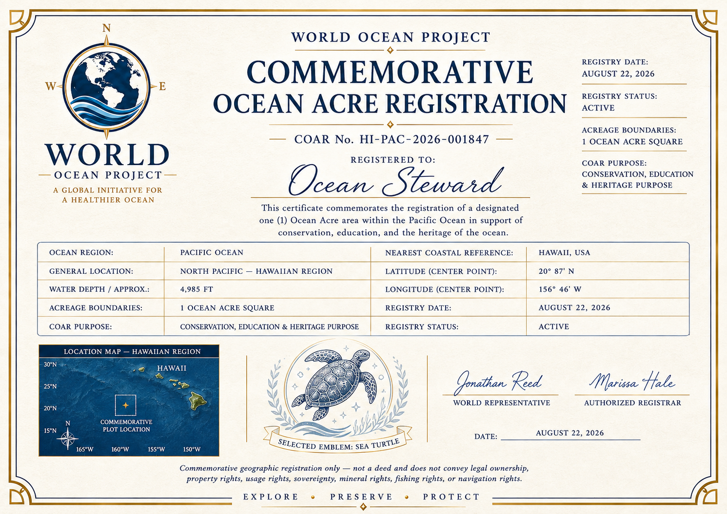
WORLD commemorative ocean acre registration certificate preview
Selected Emblem: Sea TurtleLive emblem preview — this selection is carried to the printable certificate.
OPEN FULL CERTIFICATE PREVIEW
Deed-style COAR preview using full registry number HI-PAC-2026-001847, location map, and selected emblem area. Commemorative registration only.
Plain-language disclosure

What a WORLD COAR Means

The fun can still feel official and premium without confusing a commemorative registration with legal property.

A WORLD COAR IS

  • A commemorative geographic registration
  • A collectible tied to a real ocean location
  • A unique WORLD COAR number
  • A map, coordinates and informational ocean profile
  • A gift or keepsake that can be revisited in the WORLD Registry

A WORLD COAR IS NOT

  • A deed or legal title
  • Ownership of ocean water or seabed
  • Mineral, petroleum or fishing rights
  • Exclusive navigation or access rights
  • Sovereignty or government-recognized real property
WORLD FAMILY MEMORIALS

Remember a Loved One at a Meaningful Ocean Location

A WORLD memorial can connect a loved one to an ocean location that matters to the family — including a place where ashes were scattered, a favorite coastline, a remembrance voyage, or another meaningful location.

PRIVATE

Visible only to the memorial owner.

FAMILY

Share with specifically invited family members. Exact location can remain family-only.

PUBLIC

Optionally share the memorial publicly, with approximate location shown unless the owner chooses otherwise.

WORLD does not perform or arrange the scattering of ashes. Memorial locations are commemorative records only and do not create property, access, navigation, burial, or other legal rights.

LEARN ABOUT FAMILY MEMORIALS MY MEMORIALS
WORLD Historic Wrecks & Memorial Sites

Protected Historic Locations

These locations are held as PROTECTED in the WORLD registry and are not available for general registration. A site may be reviewed for possible release at a later date. Select a location to see its latitude/longitude and move the WORLD map to that area.

Historic Site

RMS Titanic

North Atlantic wreck site and maritime memorial.

PROTECTED — HOLD FOR REVIEW
Coordinates are displayed for WORLD navigation. Some military wrecks use an official historical sinking position rather than a precise modern wreck location.

WORLD Location

LATITUDE41.7325° N
LONGITUDE49.9469° W
Status: Protected. Public purchasing remains disabled in this A-series revision.
A bigger purpose

Connect the Acre to the Ocean

Each COAR is meant to connect a remembered place to ocean geography, wildlife, and conservation information. Optional support for ocean organizations will be named clearly if a contribution program is added.

Any future donation or contribution program should clearly identify the recipient organization and the amount or percentage being contributed.